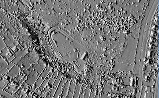
An earlier post (here) outlined some of my 'playing' with LIDAR data from the data.gov.uk web-site, this post outlines some of my results.
The main area I looked at was the high ground to the west of the 'bird sanctuary' centered at about SK317822. This area had been investigated by Archaeological Survey and Evaluation Ltd. (ASE Ltd.) in 2002 and 2006 on behalf of the Friends of Ecclesall Woods (FEW). Their reports (and others on Q-pits) can be found on the FEW web-site (www.friendsofecclesallwoods.org.uk) - I hope they will forgive me for using their results.
Writings, clippings, extracts, quotes and the like that I have collected during my browsing and digression while doing something else (the posh name is 'research', but its really digression). They started off relating mainly to Natural History (including geology and meteorology) in and around Sheffield, South Yorkshire and Derbyshire, but the odd bit of history and topographic description crept in. and now I am starting to add random 'writings'.
Monday, 5 September 2016
Sunday, 4 September 2016
Playing with LIDAR data for Ecclesall Woods, Sheffield
I decided that it was about time I resurrected my Miscellany blog after a two year break, and I thought I would start with a bit of 'playing' that I have been doing over the last few days.
John Hunter, a fellow 'researcher' who is far more knowledgeable and hard working than I am, recently mentioned that the Environment Agency has placed LIDAR data for almost the whole country on the data.gov.uk web-site - the data for the 10km square around Sheffield can be found at www.geostore.com/environment-agency/survey.html#/survey?grid=SK28 . This coincided with a walk around Ecclesall Woods here in sunny Sheffield, and I wondered whether the Q-pits and other structures that I knew existed in the woods might be visible on the LIDAR data. So that meant it was play-time!
Sure enough, lots of structures were visible, and this posting outlines the process I followed - a separate post (here) will look at what I found.
 | ||
| LIDAR Surface Model of the SMEE site at Ecclesall Woods |
John Hunter, a fellow 'researcher' who is far more knowledgeable and hard working than I am, recently mentioned that the Environment Agency has placed LIDAR data for almost the whole country on the data.gov.uk web-site - the data for the 10km square around Sheffield can be found at www.geostore.com/environment-agency/survey.html#/survey?grid=SK28 . This coincided with a walk around Ecclesall Woods here in sunny Sheffield, and I wondered whether the Q-pits and other structures that I knew existed in the woods might be visible on the LIDAR data. So that meant it was play-time!
Sure enough, lots of structures were visible, and this posting outlines the process I followed - a separate post (here) will look at what I found.
Subscribe to:
Comments (Atom)
