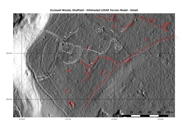
The main area I looked at was the high ground to the west of the 'bird sanctuary' centered at about SK317822. This area had been investigated by Archaeological Survey and Evaluation Ltd. (ASE Ltd.) in 2002 and 2006 on behalf of the Friends of Ecclesall Woods (FEW). Their reports (and others on Q-pits) can be found on the FEW web-site (www.friendsofecclesallwoods.org.uk) - I hope they will forgive me for using their results.
The data I used was LIDAR Digital Terrain Model (DTM) data from the data.gov.uk web-site as discussed in my earlier post (here). The data was processed as a series of raster tiles in QGIS (www.qgis.org) to produce a 'hillshaded' image simulating late afternoon summer sun coming from low in the west (azimuth 270°, altitude 30°). This gave the image shown above (click on the image for a bigger view). On the left lies the valley of the Limb Brook with the 'sunlight' brightly illuminating the eastern slope, and following the brow of the ridge the present footpaths forms two clear lines following the escarpment. On the southern edge of the image you can just see the ganister and coal workings which I believe are 19th century. Other features can be directly related to those described in the FEW/ASE papers - see image below.
Below is a further image identifying some of the key features ...
The white ellipse outlines the Hilltop Enclosure, which is thought to be Bronze Age or Iron Age, or possibly Romano-British. The yellow ellipse outlines the extent of the Field System which cuts into and therefore post-dates the enclosure - such systems are were used in the Bronze Age and possibly through to the Roman period. The red circles highlight Q-pits, which are post-mediaeval and are thought to have been used for drying wood ('white coal') for use in lead smelting. Green circles highlight what are thought to have been charcoal burning platforms. The blue line indicates a track-way or hollow-way.
More details can be found in the papers on the FEW web-site which also provide related references.
The LIDAR data is used under the Open Government Licence v3.0.


No comments:
Post a Comment